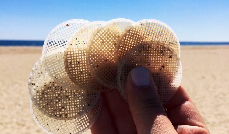
In early March 2011, I was surprised by a phone call… it was New Hampshire Department of Environmental Services, saying that we might start seeing white plastic disks on our local beaches. Thanks to some very stormy weather, an aeration tank at the Hooksett, NH wastewater treatment facility overflowed. About 250,000 gallons of water emptied into the Merrimack River, and along with it – 4.3 million plastic disks.
What Were the Hooksett Disks Used For?
The disks were designed to increase the capacity of the treatment plant. The mesh on the disks allows bacteria to grow. The disks provided more surface area for the bacteria. They could help Hooksett keep up with growing demand while maximizing its space.
Hooksett Disk Cleanup
After the spill, Hooksett hired ENPRO Environmental to conduct a cleanup. For 6 months, workers combed local coastlines and picked up disks. During those months, it wasn’t unusual for us to find thousands of the disks at one of our beach cleanups. By September 2011, the disks we no longer being found in large clusters and the paid cleanup effort stopped. But volunteers, beachgoers and walkers continued to find them along the banks of the Merrimack River and on beaches throughout New England.
Traveling Disks
The lost disks didn’t stay in the Gulf of Maine. The currents in the Gulf of Maine circulate in a counter-clockwise direction and head out of the Gulf of Maine southward. Outside the Gulf of Maine, the Gulf Stream and the North Atlantic Drift go in the opposite direction, bringing water northward and across the Atlantic to the east. We’d heard tales of New England and Canadian lobster gear ending up on European beaches, so perhaps it shouldn’t have been too surprising that we started getting disk reports from Europe as well. Since the spill happened, we’ve gotten reports from England, France, Scotland and Norway!
Disk Reports
After getting many informal disk reports over the years, we worked with UNH Cooperative Extension to create a map to collate all the current disk sightings and collect future sightings. This way we can continue tracking disk sightings and see how long they continue to show up. We have also used the map for educational purposes, to show how far litter can travel and how long it persists in the marine environment.
Below, you can check out this map – see sightings and report your own by clicking the blue button. We look forward to receiving your reports!